Cite report
IEA (2024), Global Methane Tracker 2024, IEA, Paris https://www.iea.org/reports/global-methane-tracker-2024, Licence: CC BY 4.0
Progress on data and lingering uncertainties
Data on methane emissions is more available than ever, but large uncertainties still exist
Robust and verified methane data is important for setting reduction targets, establishing baselines, and tracking progress over time. There has been a large increase in the availability and reporting of methane emissions data in recent years, but estimates are still subject to a high degree of uncertainty.
Some of the largest differences are between data based on measurement campaigns and scientific studies, and those reported to official public bodies and by companies.
The most recent comprehensive assessment of all sources of methane emissions – provided in the Global Methane Budget – suggests that methane emissions from oil and gas operations are around 84 Mt, broadly similar to our estimate. In contrast, the sum of country-level figures submitted by national governments to the UN Framework Convention on Climate Change (UNFCCC) is around half of this amount.
Range of reported and estimated methane emissions from oil and gas operations
OpenEstimates implied by company-level reporting are even lower. For example, company reports to the Oil & Gas Methane Partnership 2.0 (OGMP 2.0) – which covers around one-third of global oil and gas supply – suggest that an average of 0.6 kg of methane is emitted across the oil and gas supply chain per tonne of oil equivalent of oil and gas production. If these companies were to fully represent the industry globally, then global oil and gas methane emissions would be around 5 Mt, about 95% lower than our estimate and that reported in the Global Methane Budget. A similar result is found with companies reporting to the International Association of Oil and Gas Producers.
There are many possible reasons for these differences. For example, many official greenhouse gas submissions to the UNFCCC have not been updated for years. It is also likely that those that report emissions to OGMP 2.0 are among the better performers or otherwise more motivated to act on methane, and so are not fully representative of the broader industry.
Still, a major issue is likely that the inventories generated by most countries and companies rely on bottom-up approaches that use activity or emissions factors that are not based on recent measured data. As a result, they may be underestimating potential emissions sources; they may also be missing “super-emitting” events – the large, often accidental leaks that can be responsible for an outsized share of overall emissions levels.
Another major cause of uncertainty is the lack of data transparency and disclosure. Companies that are part of OGMP 2.0 have committed to report emissions at detailed level for all operated and non-operated assets within a set timeframe. But progress to date has been slow, and not all companies have joined transparency initiatives. Some companies have claimed that there are commercial sensitivities to reporting methane at a detailed level, but they could do much more to explain why this is the case and help advance solutions to allow for greater scrutiny of reported data. This is essential to build regulatory and public confidence in actions that are being taken, and it is particularly important for companies looking to make the case that they have already achieved a very low methane emissions intensity.
Despite the uncertainty that exists, the low level of methane emissions, verified by measured data, seen in number of producing countries – for example, in Norway and the Netherlands – highlights that it is already perfectly possible for a producer to attain a sustained low emissions intensity. Although there are still gaps in our knowledge of methane emissions today, more than enough is known to state categorically that the world can and must act rapidly and decisively on methane.
Satellites are providing a step change in our understanding of emissions but gaps remain
Advances in direct measurement techniques by land and air, notably from satellites, are allowing for more – and more reliable – information on methane emissions, with a wide range of resolution over time and geographies. Current satellite technology and advancements in data processing techniques, such as the use of neural networks, cloud computing and artificial intelligence, are being used to detect and quantify total emissions from major leaks over a large area, down to small leaks at the facility level.
Satellites enable regional estimates of total methane emissions over longer periods of time. Some of these processes are in their infancy, but they are providing a better understanding of the location and frequency of methane emissions. These advances in satellite and other remote‑sensing technologies will bring greater transparency, improve quantification, raise public awareness, and support regulatory oversight.
A major advance in satellite-based readings is expected in 2024. MethaneSat, a new satellite backed by the Environmental Defense Fund (EDF), was successfully launched in March 2024. It aims to provide high spatial resolution and precision, with frequent readings over a large geographical scale that are combined with advanced computational techniques and automation.
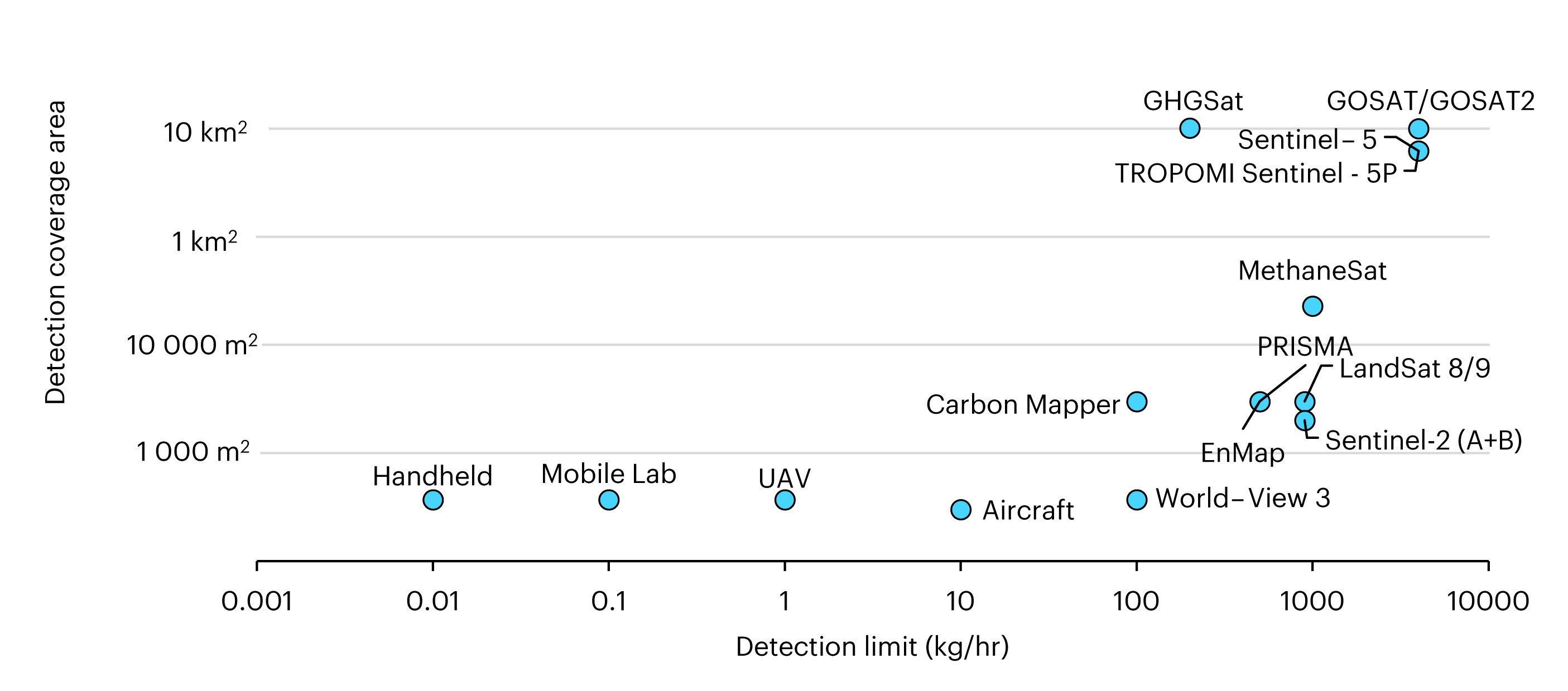
Detection coverage area and emissions limit for methane detection devices
Open
Information on selected satellites with methane detection capabilities
|
Name |
Start year |
Revisit time (days) |
Data collection method |
Spatial resolution (pixel size) |
Detection limit (kg/hr) |
Retrieval swath size (km) |
Data access |
|---|---|---|---|---|---|---|---|
|
2009 |
3 |
Continuous |
10 x 10 km |
7000 |
790 |
||
|
2018 |
3 |
Continuous |
10 x 10 km |
4000 |
790 |
||
|
2017 |
16 |
Continuous |
7 x 5.5 km |
4000 |
2600 |
||
|
2024 |
7-14 |
Continuous |
0.1 x 0.4 km |
500 |
200 |
||
|
2013 |
16 |
Continuous |
30 x 30 m |
900 |
185 |
||
|
2021 |
16 |
Continuous |
30 x 30 m |
900 |
185 |
||
|
2015 |
5 |
Continuous |
20 x 20 m |
900 |
290 |
||
|
2017 |
5 |
Continuous |
20 x 20 m |
900 |
290 |
||
|
2019 |
7 |
Tasked |
30 x 30 m |
500 |
30 |
||
|
2022 |
4 |
Tasked |
30 x 30 m |
500 |
30 |
||
|
2022 |
ISS dependent |
Tasked |
60 x 60 m |
500 |
75 |
||
|
2014 |
1 |
Tasked |
3.7 x 3.7 m |
TBD |
13.1 |
||
|
2016 |
14 |
Tasked |
25 x 25 m |
100 |
12 |
||
|
2024 |
1-7 |
Tasked |
30 x 30 m |
100 |
18 |
Notes: Retrieval swath size = horizontal distance a satellite covers along its orbit as it retrieves readings. For GHGSat, a single satellite has a 14-day revisit time and there are 11 operating satellites in orbit. EMIT is hosted on the International Space Station (ISS). MethaneSAT's detection limit for total emissions is 5 kg/hr per km2.
Information on selected land and air-based deployment methods for methane detection
|
Deployment |
Technology |
Spatial Resolution (m) |
Swath (km) |
Routine Coverage Time |
Detection Limit (kg/hr) |
|
|---|---|---|---|---|---|---|
|
Aircraft |
LiDAR (light detection and ranging) |
2 |
128 |
Several hours |
1-2 |
|
|
AVIRIS-NG (Airborne Visible InfraRed Imaging Spectrometer - Next Generation) |
0.3-4.0 |
2-11 |
5-6 hours per flight |
15-84 |
|
|
|
Fixed, Vehicular, Handheld |
Optical gas imaging |
meters |
0.1 |
Continuous |
3-30 |
|
|
Unmanned Aerial Vehicle Mobile Laboratory Handheld |
Optical gas imaging; Cavity ringdown spectrometers; Laser absorption spectroscopy |
meters |
Typically 0.001-10 |
Scheduled |
0.1-30 |
|
Methane emissions were detected by satellite and reported by the analytics firm Kayrros in around 70 countries in 2023. The data indicate some good and bad performers. For example, in Turkmenistan, more than 250 high-emissions events were detected over 90 days of coverage that was possible in 2023; in Saudi Arabia fewer than 10 events were observed in more than 110 days of coverage that was possible. On the remaining days, cloud coverage or other interference prevented observations from taking place. In Kazakhstan, a well blowout in the Karaturun East oil field lasted for more than 200 days, and satellite-based estimates indicate that it likely accounted for more than 0.1 Mt of methane emissions – about 10 times our estimate of all oil and gas methane emissions from Norway in 2023. In total, satellite-detected large methane emissions represent around 5% of our total estimate of methane emissions from fossil fuels in 2023. This number is expected to increase with better satellite coverage and resolution provided by new instruments launching throughout 2024 such as MethaneSAT.
Satellite-detected large methane emissions, 2019-2023
OpenIn contrast to the satellites with large detection areas that can be used to detect unexpected emissions events, some satellites – such as those used by GHGSat – have a much finer resolution and can be targeted at specific locations. In 2023, GHGSat's satellites were able to carry out around 13 000 daily observations at specific oil, gas and coal facilities. It was most often tasked to observe facilities in Eurasia, North America, the Middle East and Australia. In total, GHGSat satellites observed around 8 000 methane emissions events from oil and gas operations and nearly 3 000 from coal operations (in some instances, multiple emissions events at different locations were seen within a daily observation of a facility).
Most comprehensive measurement campaigns and targeted satellite-based activities have to date focussed on the United States and Canada, providing a clearer picture of methane emissions in these countries. There has been fewer measurement data collected and reported for a number of major emitters – including Russia, Venezuela, India, China, Brazil and Nigeria – and uncertainty over emissions levels in these countries is significantly higher.
Satellite-detected fossil fuel methane events, 2023
OpenData from satellites with different spatial resolutions and detection limits are now being combined to provide further insights on emissions. For example, in 2023, data from Sentinel‑5P processed by Kayrros reports that 152 methane super-emitter events in the United States could be from oil and gas operations across an average of 35 days per US state when observations were possible. Accounting for the level of coverage, this implies that large leaks emitted around 3 Mt of methane in 2023.
Data from Sentinel-2 processed by Orbio reports an average of 40 observation opportunities per year for oil and gas assets in the United States. Accounting for the frequency of observation opportunities, these data suggest that around 10 Mt of methane was emitted from upstream oil and gas onshore operations in 2023 (around three-quarters of our total estimate of oil and gas methane emissions for the United States in 2023). Sentinel 2 has a lower detection threshold and higher spatial resolution than Sentinel-5P, so it likely provides a more complete picture of emissions levels within a region. However, it has a lower revisit frequency and therefore cannot provide global coverage on a daily basis.
Despite their great potential, satellite data and resulting estimates of emissions are not a panacea. Existing satellites can struggle to provide readings in some environments such as offshore areas (despite some progress in this in recent years), mountain ranges, snowy or ice-covered regions, and at high latitudes. Satellite readings are also impaired by cloud cover; even if only a portion of the monitored area is covered, this limits the number of days when detections can be made. For example, countries with dense forests or those in equatorial regions, such as Nigeria or Venezuela, are often very cloudy, hindering observation efforts.
Data processing is also computationally intensive and there can be a lag between observations and reporting. As a result, many countries have little timely data on emissions rates, and observations may miss sporadic leakages. This situation is improving with advanced processing techniques, the automation of detection data, and the use of artificial intelligence, which could together bring greater and faster visibility to potential hotspots.
The Methane Alert and Response System shows how satellites can aid abatement
Satellites are providing a major to boost transparency on emissions levels; they can also be used to advance mitigation efforts. The UN Environment Programme’s Methane Alert and Response System (MARS) launched at COP27 uses satellites to detect major methane emission events and then alerts the country where it is occurring and the involved operators or company. For unexpected leaks, this can allow for faster action to address the underlying cause. The MARS programme also supports companies and governments to use the data for strategic mitigation plans.
In the first nine months of 2023, MARS detected 500 large methane emissions events from oil and gas operations globally and delivered around 80 notifications to countries or companies. Events not associated with a notification generally occurred because countries had not nominated the main contacts within the relevant agency. Once they are nominated, MARS is able to flag any detections and assist countries in tackling the emissions event.
Number of detected emissions and notifications by MARS, January-September 2023
OpenMARS has the potential to address methane emissions from super-emitter events, but a large number of countries have not yet actively engaged with it. Indeed, most countries that have signed the Global Methane Pledge (GMP) have not nominated a main point of contact to be notified of satellite-detected events through MARS. This would be a valuable step in converting the GMP pledge into action.
There are a growing number of companies looking to provide notifications of methane emission events, including Airmo, GHGSat, Kayrros and Orbio Earth. These use a variety of satellites and differing techniques for data processing. As data processing algorithms for satellite data improves, there will be even greater potential for this data to drive action on methane reduction.
Stronger reporting is needed to help policy makers, regulators and companies, and to boost public confidence in abatement efforts
Measurement, monitoring, verification and reporting (MMRV) of methane emissions is a key component of managing methane emissions and making progress towards climate goals. A number of initiatives and groups have been working on MMRV standards for oil and gas operations. This includes:
- The Oil & Gas Methane Partnership 2.0 (OGMP 2.0), a UNEP programme with a mandate to provide a comprehensive framework for emissions reporting and mitigation. OGMP 2.0 documentation encompasses technical implementation and reconciliation guidance as well as reporting templates, specific to all oil field activities from well head to LNG regasification. End users and partners can use these resources to design and implement their MMRV programs.
- An international working group on MMRV, announced in November 2023, which includes Australia, Brazil, Canada, Colombia, the European Commission, France, Germany, Italy, Japan, Norway, the Republic of Korea, United Kingdom, and the United States of America. This builds on OGMP 2.0 and pledges to advance comparability across measurement and reporting methods, and offer accreditation for certifiers. It aims to help move towards consensus on MMRV frameworks, allowing companies and countries to measure and report in a consistent manner.
- The International Association of Oil and Gas Producers (IOGP), Ipieca (originally the International Petroleum Industry Environmental Conservation Association), and the Oil and Gas Climate Initiative also provide supporting material for MMRV efforts. They released a methane detection and quantification technology filtering tool to accompany their recommended practices report in 2023.
Finally, a number of companies, including MiQ and Project Canary, are also developing MMRV products and services for oil and gas operators. These often rely on public frameworks, measurement instruments and protocols, as well as bespoke tools and workflows to help companies and countries achieve net positive MMRV programs and results.
These programmes can help companies more quickly develop and apply robust MMRV. However, there is an emerging risk that the proliferation of new standards could lead to inconsistencies and confusion between the emissions levels reported by different companies. Close coordination and cooperation between groups, alongside greater transparency in emissions reporting, will be important to avoid this.